Virginia: Where the Court Decides
After enduring a long, ugly history of gerrymandering, Virginia voters approved a new redistricting process in 2020.
Topline Takeaways
Virginia’s new congressional districts were drawn and approved by the state Supreme Court after the state’s bipartisan redistricting commission failed to agree on new district boundaries.
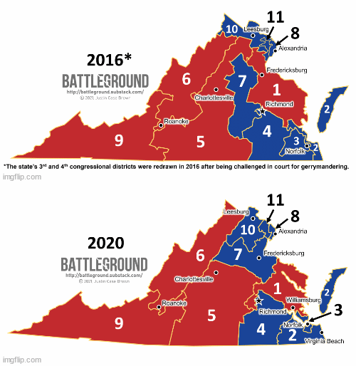
Districts underwent significant changes since the previous map was created via a partisan process controlled by Republicans. (In 2010, Virginia’s maps were created by the legislature and approved by the governor.)
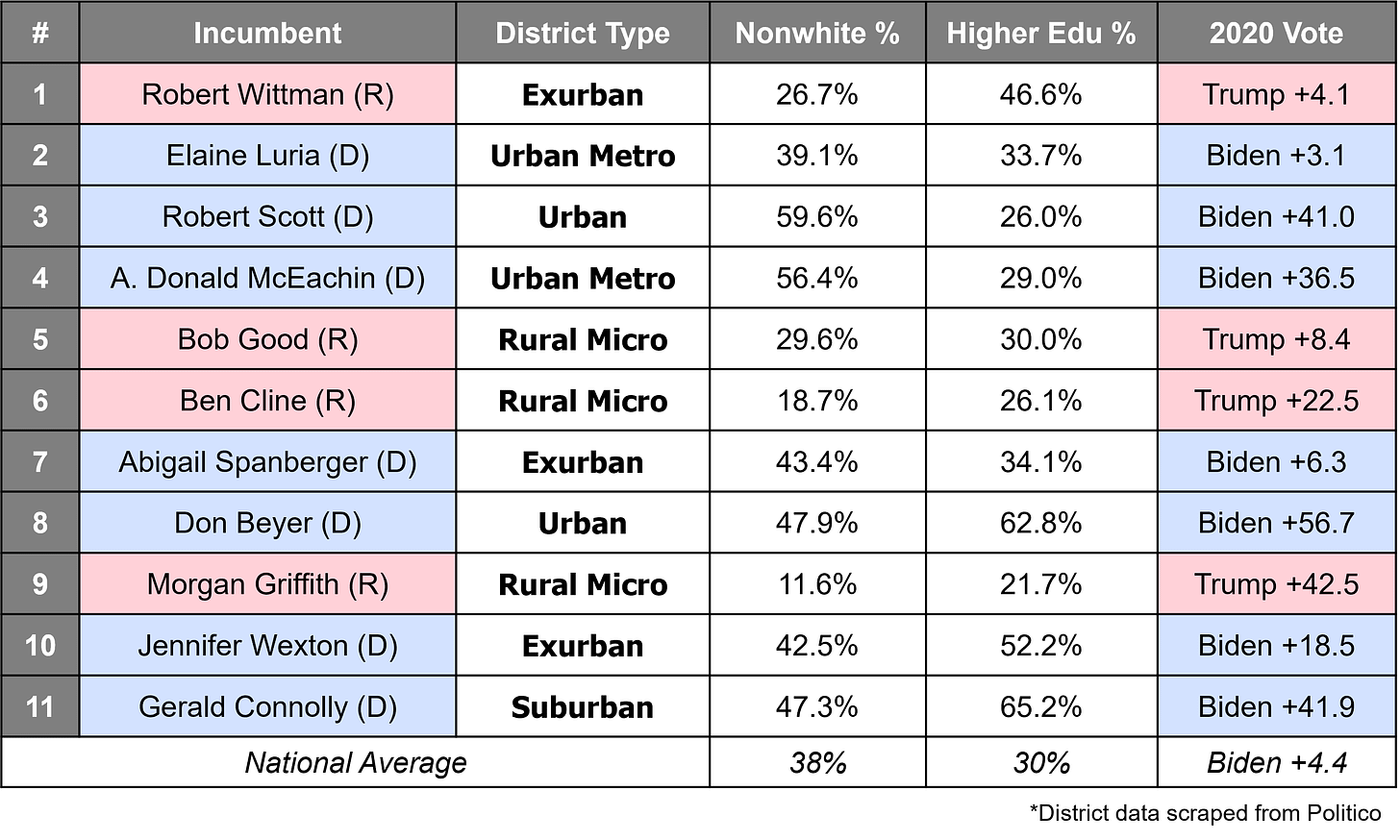
Despite significant changes in boundaries, the partisan balance of the map is about the same as the previous map. It retains the same number of competitive and safe seats for both parties.
Who’s In Control?
For the 2020 redistricting process, Virginia implemented a new process to decide district boundaries. Previously, the state legislature drew boundaries that had to receive gubernatorial approval. This resulted in some of the most gerrymandered districts in the nation’s history.
In the 2020 election, Virginia voters supported a constitutional amendment overhauling the state’s redistricting process. It established a bipartisan commission to determine new boundaries that would be approved or denied by the state legislature. Under the new amendment, the legislature only has approval power and may not amend the maps submitted by the commission. If the legislature rejects the commission’s proposal, the commission has one shot to revise the map for a second vote. If the revised map still fails to pass the legislature, the process falls completely into the hands of the state Supreme Court. In this first run of the new process, the 16-member commission failed to draw a map to the legislature’s liking, therefore the new map was drawn and approved by the state Supreme Court.
(Justices on the court approved two “special masters” to draw the new map, each nominated by one of the major state parties. After the special masters created new boundaries, the new map received public comments. The special masters amended their proposal based on those comments and the final map was approved by the state Supreme Court.)
New District Breakdown
Changes to Virginia’s congressional map make the state’s districts much more compact, rather than stretching north-to-south across the state. The most visible district changes are in the center of the state in VA-1, VA-5 and VA-7. The state’s first district, anchored in the three “necks” of Virginia, no longer stretches up to Fredericksburg and the DC suburbs and instead sticks close to Richmond. VA-7 takes on those Fredericksburg voters and groups them in with exurban voters living on the outskirts of either the Washington DC or Charlottesville metro areas. These changes shift VA-7 slightly toward Democrats while still keeping the district competitive. Meanwhile VA-5 is transformed from a long district lying east of the Blue Ridge Mountains into the “Southside” district, a region of the state lying east of the Fall Line, west of the mountains and south of the James River. The new VA-5 is anchored by Charlottesville at its northernmost point.
VA-2 will be a district to watch in the upcoming elections. Areas in the new VA-2 (Virginia Beach, Chesapeake and Norfolk’s suburbs) are largely responsible for Youngkin’s recent gubernatorial win. Many of these municipalities are among Virginia’s largest and flipped from supporting Democrats in 2020 to voting Republican in 2021. The current House incumbent, Democrat Elaine Luria, will likely face a fierce battle this year to defend her seat as changes to the district tilt it slightly in favor of Republicans.


